
Fish Reef Se.arch Monitoring
In order to systematically implement the renewal and reconstruction work of coastal fishing grounds, the government can effectively prevent the aging of fishing grounds and improve the bottom environment of sea areas. And provide fish habitat and breeding grounds to improve productivity in coastal waters. A large number of artificial fish reefs are produced and placed, and various fish reefs are used to cultivate fishery resources. Further prevent all kinds of trawlers from intruding into the coastal waters to achieve the goal of conserving the fishery resources in the coastal waters of the province.
The selection of the artificial reef placement site needs to consider its hydrological and ecological environment, seabed bottom quality, seabed topography and other factors. The multi-beam sounding system was used to measure the artificial ship reef off the coast of Tainan. After the actual measurement and various corrections, and after filtering the data, a more representative iron-hulled ship was found. In the way of numerical terrain model, the water depth color scale classification method is used to draw an image as shown in the figure. We can clearly distinguish the seabed topography near the ship reef and the condition of the ship reef on the seabed. If there are more than two ship reefs, each ship can be clearly distinguished, as shown in the figure. It can also be rotated at any angle to observe the various states of the ship on the seabed, such as whether there is brush depth around the ship, accumulation, ship displacement, etc.
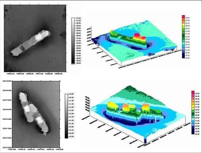

Image map of artificial ship reefs (iron-hulled ships) off the coast of Tainan measured with a multi-sound beam sounding system (upper left) stereogram (upper right) Image map of two ship reefs (bottom left) stereogram (bottom right).